Defining Spatial Extents in a Settings File
The import process can specify a spatial extent to limit the amount of data being imported. You can set this with a fence or specify a view.

If the Save Spatial Extents option is set to True then the following will happen:
-
If a fence or the specified view is active when the settings file is saved, then the fence or view coordinates will be saved in the settings file.
-
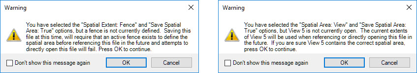
If a fence is not defined, or the selected view is not open, then the coordinates of the spatial extents will not be saved in the settings file. A warning error dialog will explain that a spatial extent was not found and that one must be available when the file is referenced for that IMPX file to operate. Press OK to save the IMPX file without spatial extent coordinates or Cancel to not save the file.
When attaching an IMPX file as a reference, the saved coordinates will be used as the spatial extent for the reference attach, reference reload and when the file is reopened.
Without saved coordinates, the following will occur:
-
Reference Attach – The currently active fence or view will be used. If the specified view is not active or there is no fence defined, then an error message will be output to the message center.
-
Reference Reload – The currently active fence or view will be used. If the specified view is not active or there is no fence defined, then an error message will be output to the message center. The reference file must be forced to reload by using the keyin reference reload force.
-
File Reopen – No data loaded because the active model has yet to be established. Use the keyin reference reload force to load the IMPX file.